Miranda-Max de Beer

Red Herring: Dismissing Distraction
This redesign of Draw Seven State Park began as an assignment for RISD’s Fall 2022 Advanced Studio, “Darkness as a Medium of Vision.” Red Herring is a response to the multi-million-dollar Vegas-style hotel and casino that looms over the riverside park on the opposite shore. The project poses questions about the history and health of communities living in and around the lower Mystic River in Massachusetts. Does not acknowledging entire chapters of an area’s past serve the best interests of its future?
The Mystic River and Herring Migration

Map of the Mystic River watershed. (Image source: Mystic River Watershed Association)
Only 76 square miles, the Mystic River watershed is where over 600,000 people call home, making it among the most urbanized watersheds in New England (1). Sitting on lands colonized from the Massachusett, Pawtucket, and Nipmuc peoples, "Mystic" is derived from the English-language bastardization of the river's indigenous name, Missi-Tuk, or “great tidal river” (2).
The Mystic plays a key role in herring reproduction and population sustenance. Alewife and blueback herring are collectively referred to as river herring. Both species primarily live in the ocean but migrate back to freshwater to reproduce upon sexual maturity (3 to 5 years old). This staggered cycle means river herring are diadromous fish, a group that comprises less than 1% of all species of fish (3).


Alewife and blueback herring. (Image source: Duane Raver, U.S. Fish and Wildlife Service, Wikimedia)
For indigenous communities, both modern and historic, the run of the river herring holds great cultural significance (4). Urbanization, the construction of dams, and overfishing at sea led to sharp declines in yearly migration and breeding population numbers in the Mystic. Efforts such as protected-species legislation and the installation of fish ladders at dams have led to the bouncing back of river herring populations (5). Organizations such as the Mystic River Watershed Association (MRWA) spearhead such endeavors and track their effects. Each year during herring migration season, the MRWA organizes a herring count (6). Data collection relies on citizen science. Volunteers count fish migrating up the Mystic Lakes Dam fish ladder in 10-minute increments from seven in the morning to seven at night between April and June. This methodology was adapted to accommodate a continued effort during the coronavirus pandemic: people could log online to view MRWA’s “Fish Cam” and participate in leaderboard rankings (7). In 2024, citizen scientists working with the MRWA counted over 640,000 herring passing through the Mystic Lakes fish ladder, the largest count in the state (8).
Impending Change
The Mystic, in addition to its significance to indigenous culture and herring ecology, played a key role in the industrialization of the United States. Industry continues to operate in and around the densely populated watershed.

Change over time: industrial land parcel designations (1971-2016).
Like many modern coastal cities, the greater Boston area is no stranger to the threat of climate-change-induced sea-level rise or storm surges. Historic infill of marshy parts of the Mystic and neighboring Charles Rivers took away natural flood prevention systems, while modern waterside development leaves little room for rising water to go. Both historic and modern industrial sites find themselves in the crosshairs of rising waters. How will the influx of surficial floodwaters and a rising water table interact with harmful substances steeped into the ground, left behind and forgotten as industrial sites change?

Historically industrial parcels overlain by projected sea level rise (in feet).
Area History (Encore and Assembly Row)

Map of commercial landmarks and major transportation corridors surrounding the project site.
The land around the confluence of the Mystic and Malden Rivers has witnessed incredible transformation over the last few centuries. Once healthy enough to support farms and oyster beds, the lands and waters of the lower Mystic have been marred by heavy industry and chemical spills. Now home to projects like a glittering urban multi-use development, a big-box shopping center, and a hotel straight out of Las Vegas, residents are advised against consuming anything grown in existing soil or fish caught in the river.
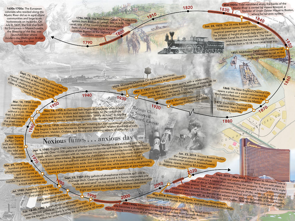
History of development and pollution around what are now Assembly Row, Gateway Center, and the Encore. (Click image to expand)
Site Conditions

Aerial view of Draw Seven State Park. (Image source: Google Earth)
Draw Seven Park, about nine acres, is mainly an undeveloped space sandwiched between subway tracks and the Mystic. A paved walkway connects Assembly Row to the Alford Street bike path. A small picnic hut neighbors the parking lot while a fishing pier juts out over the river. The large and open park is rife with ruderal species, opportunistic plants that can accommodate themselves to grow in former industrialized landscapes. The site’s underlying geology and soil ecology are typical of filled-in tidal marshes. Surficial material consists of rubble, sand, gravel, and dredged material. The substratum, being on the banks of the Mystic, lends to surface pooling after heavy rainstorms (9).


The park is enjoyed by walkers and bikers, picnic-goers, canine frisbee catchers, soccer players, and fisherpeople. Though warned against eating catches, those who fish at Draw Seven have created a hyperlocal culture that brings people into a dialectic with a river whose recent history has often forced it to turn them away.


Left: Fishing pier at Draw Seven State Park.
Middle: Lures hang from a fence between the park and subway tracks.
Right: Signs warning the public against eating most seafood caught in the Mystic River.
Design Proposal
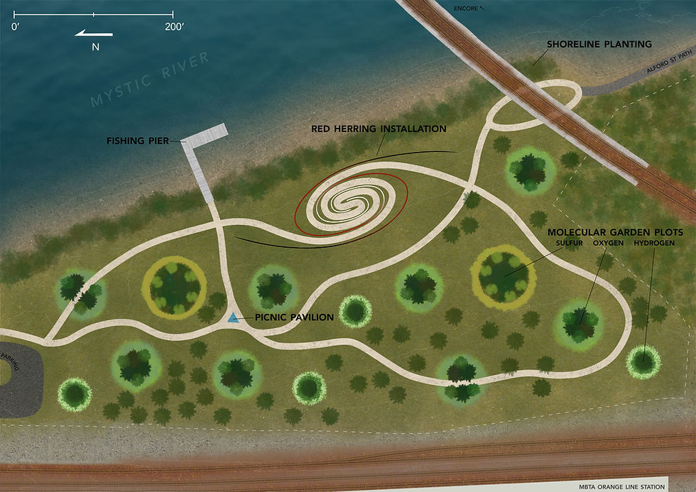
My proposal calls for two larger-scale design elements: an immersive sculptural installation–“Red Herring”–and Molecular Garden plots. The addition of a covered picnic pavilion serves not only those enjoying a meal but also those who need a place to prepare their lines and lures. A shoreline planting scheme doubles as soil stabilization and light flood mitigation. The existing fishing pier will remain untouched.

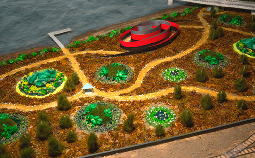


Red Herring Installation
Red Herring serves as a reminder to those able to see it, near or far, that what we see on the surface is not always the entire story. Its title is derived from the term that references a distraction from an issue at hand. The piece acts as a reminder to residents and visitors of Assembly Row and the Encore Boston Harbor of the importance the river has to herring, the area’s industrial past, and the possibility that the hidden legacy of pollution will reemerge given current sea-level rise projections.
The installation invites visitors in by wrapping itself around them. Two spiraling curves grow from the ground up to 40 feet tall and extend 300 feet horizontally. Each curve is covered in lightweight and life-sized vacuum-formed herring, mimicking the feeling of being enveloped in a school of herring (such as the one seen in this YouTube video).

Step-by-step diagram showing the major components of the Red Herring installation.
The color transformation of the adorned fish serves more than an aesthetic purpose. Closest to the ground are mutated fish, modeled after the product of the chemical reaction between sulfuric acid and sugar (10). Moving upwards, the grotesque morphs into a literal red herring. At the top, red turns to a lifelike silvery-blue. The immense size and labyrinthine layout of the installation, combined with the gradient of color-changing herring, prompts visitors to think about the symbolism of that change while simultaneously feeling caught up in the enormity of it.

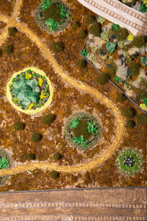
Molecular Garden
The Molecular Garden is a continuation of the Red Herring narrative. When viewed from above, each garden plot sits about its neighbors in an abstracted rendition of two ball-and-stick models of sulfuric acid, H₂SO₄. These magnified molecules, botanical acid in the ground, serve to educate about a history of repeated chemical spillage. They invite visitors to think about what it means to “clean up” after a spill. How can we possibly account for every molecule that seeps into soil, taints water, or evaporates into the air? Is the solution to send contaminated soil to parts unknown and declare it “not our problem anymore?”

Molecular Garden plot layout. S = sulfur, O = oxygen, H = hydrogen.
The plant species in each elemental plot were deliberately chosen as a nod to the element they represent:
Sulfur is a yellow element. In organosulfur compounds, sulfur appears in many formats, ranging from fragrantly delicious alliums to less appetizing fossil fuels (11). Thus, selected species have visual or olfactory characteristics that align with those of sulfur and its forms.
Oxygen is key to any organism that relies on respiration, a cycle of filtration. Species chosen for these plots participate in multiple kinds of filtration, including phytoremediation.
Hydrogen is the lightest and most abundant element in the universe. The kinds of plants chosen for these plots float delicately above the ground. Most can be found in abundance along New England interstates.


Species distribution diagrams for each elemental plot.
The edges of each elemental plot are loosely maintained and redefined with semi-seasonal mowings. In between mowings, the grass around each plot and the species lining their circumferences begin to blend, making the boundary between sulfuric acid and the surrounding land indistinguishable.


Conclusion
The damage done by industry will never be completely reversed and the effects of leaked toxins will continue to pose a threat to the environment and all its residents around the Encore and Assembly for years to come. Red Herring questions those who attempt to ignore or obscure an area’s messy histories. It invites those who are unfamiliar to get to know where they live and the injustices it and its past inhabitants have faced. It asks visitors to contemplate a future of placing precedence on environmental and public health rather than industry and profit.
Sources
Mystic River Watershed Association, “Mystic River Watershed,” ArcGIS, n.d., https://www.arcgis.com/apps/View/index.html?appid=e42d5a9dbd1d4d0ba3d82a47f90000d7.
Mystic River Watershed Association, “River History,” Mystic River Watershed Association, n.d., https://mysticriver.org/history.
Mystic River Watershed Association, “Mystic River Herring Run Is the Largest in the State for 2024,” Mystic River Watershed Association, November 27, 2024, https://mysticriver.org/news/2024/11/25/mystic-river-herring-run-is-the-largest-in-the-state-for-2024.
Robin Cohen, “Mashpee Wampanoag: Celebrating River Herring,” Mystic River Watershed Association, May 3, 2021, https://mysticriver.org/news/2021/5/3/mashpee-wampanoag-celebrating-river-herring.
Mystic River Watershed Association, “The Amazing Return of Mystic Herring,” ArcGIS StoryMaps, December 5, 2023, https://storymaps.arcgis.com/stories/be565b61b9d64128852f5ae20749fa82.
Danielle Davidoff, “Mystic River Herring Education Project,” SciStarter Blog (blog), January 11, 2019, https://blog.scistarter.org/2019/01/mystic-river-herring-education-project/.
Barbara Moran, “One Fish, Two Fish: This Year’s Mystic Herring Count Goes Online,” WBUR, May 29, 2020, https://www.wbur.org/news/2020/05/29/mystic-river-herring-count-pandemic.
Mystic River Watershed Association, “Mystic River Herring Run Is the Largest in the State for 2024.”
Thomas A. Peragallo, “Soil Survey of Norfolk and Suffolk Counties, Massachusetts,” Soil survey (United States Natural Resources Conservation Service, September 1989), http://nesoil.com/norfolk/Ue.htm.
Anne Marie Helmenstine, “Perform the Sulfuric Acid and Sugar Chemistry Demonstration,” ThoughtCo, September 1, 2021, https://www.thoughtco.com/sulfuric-acid-and-sugar-demonstration-604245.
Eric Block, “Organosulfur Compound,” Britannica, n.d., https://www.britannica.com/science/organosulfur-compound.
For sources used in diagrams and imagery above, please see the Appendix: